 Social Liberty
Councils of the US 2026
In 1643 four New England colonies sent two commissioners each to a standing council. Here are nine regions of today's states, each with a council of its senators and governors, the people already elected statewide.
Click to enlarge
In 1643 Massachusetts Bay, Plymouth, Connecticut, and New Haven formed the United Colonies of New England. Each colony sent two commissioners, and any decision needed six of the eight votes. The confederation handled what no single colony could, chiefly defense and disputes between the colonies, and left each one’s internal government alone. Rhode Island, which the others regarded as a refuge for heretics, was refused admission. Eleven years later, at Albany, Benjamin Franklin proposed a Grand Council for all the colonies, its members chosen by their own assemblies. Every colonial assembly that took up the plan rejected it, and the Crown never adopted it.
The regional dispatches in this collection, from The River Decides What Seven States Couldn’t to Longest Warrant, keep finding problems shaped like a region rather than a state: a river shared by seven states, a property-tax fix that one state has run for a century while its neighbors ignore it, a transit corridor that crosses town lines. Some of these already have regional bodies. Most are left to Washington or to no one.
The councils below take the simplest membership available: every U.S. senator and every governor from the states in each region, three members per state. Each state counts equally, as the colonies did in 1643, and every seat goes to someone already elected statewide. The mix of levels is deliberate. Until the Seventeenth Amendment in 1913, state legislatures chose senators, and a council of senators and governors would have been a creature of the states alone. Today senators are federal officers elected by the same statewide voters who elect governors, so such a council would sit across both levels, as the few existing regional bodies with real authority already do. The Delaware River Basin Commission, formed in 1961, joins the governors of Delaware, New Jersey, New York, and Pennsylvania with a federal commissioner. The Appalachian Regional Commission pairs a federal co-chair with the governors of thirteen states.
The regions follow the Census Bureau’s nine divisions, the same lines the dispatches use. The District of Columbia has neither a governor nor senators, so it has no seats, though it sits inside the South Atlantic and shares its transit system under a compact with Maryland and Virginia. The rosters are as of October 20, 2026. The November 3 election will decide 35 Senate seats and 36 governorships, so many of these names will change in January.
The councils
New England
The region already has the habit. The New England Governors and Eastern Canadian Premiers have met annually since 1973, the six states share one electric grid run by ISO New England, and all six joined the Regional Greenhouse Gas Initiative when it began in 2009. Its council would have the highest share of independents, two of eighteen, and the closest tie to 1643.
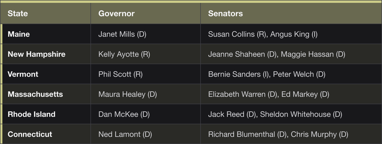
Council of 18: 13 D, 3 R, 2 I.
Middle Atlantic
The smallest council, nine members, presides over the country’s oldest working interstate agencies. The Port Authority of New York and New Jersey dates from 1921, and the Delaware and Susquehanna river basin commissions both bind these states to federal partners. The Region That Already Ran the Experiment found the region’s property-tax argument split three ways across one shared problem.
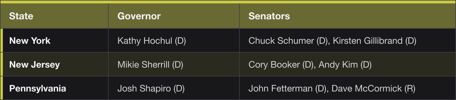
Council of 9: 8 D, 1 R.
South Atlantic
Eight states and the most even council, twelve to twelve. The Atlantic States Marine Fisheries Commission, formed in 1942, already manages the coast’s shared fish stocks, and Maryland and Virginia run the Washington Metro with the District under a 1967 compact. The longest dispute inside the region, Georgia against Florida over the Apalachicola–Chattahoochee–Flint river system, has gone to the Supreme Court more than once without being settled.
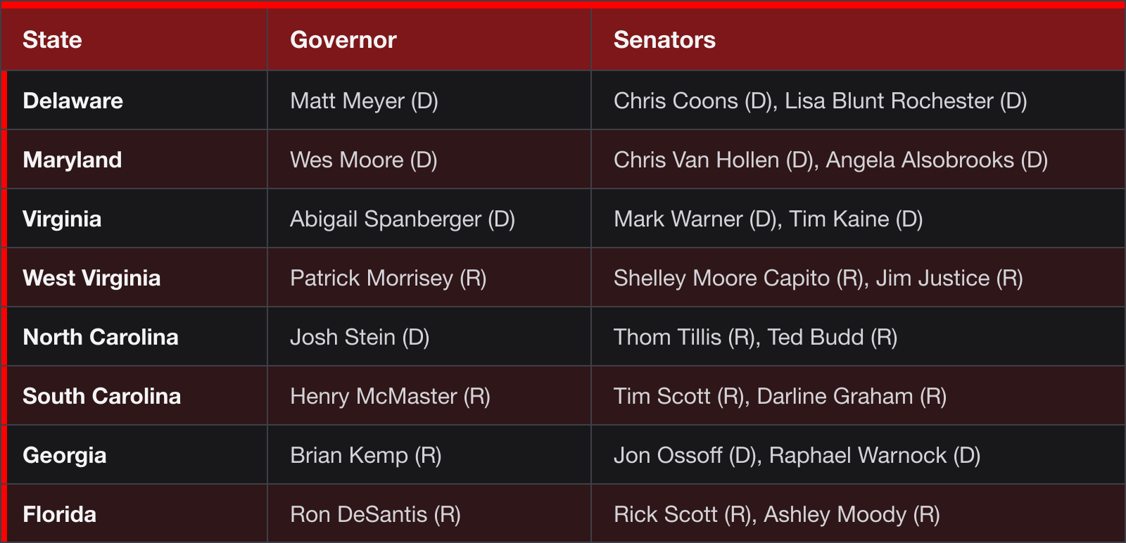
Council of 24: 12 D, 12 R.
Lakes
The Great Lakes Compact, approved by Congress in 2008, already gives the region’s governors, along with those of Minnesota, New York, and Pennsylvania, a joint veto over large diversions of lake water. What November Reassembles found five states arguing over the same land-tax and map-drawing questions in parallel, none of them talking to the others.
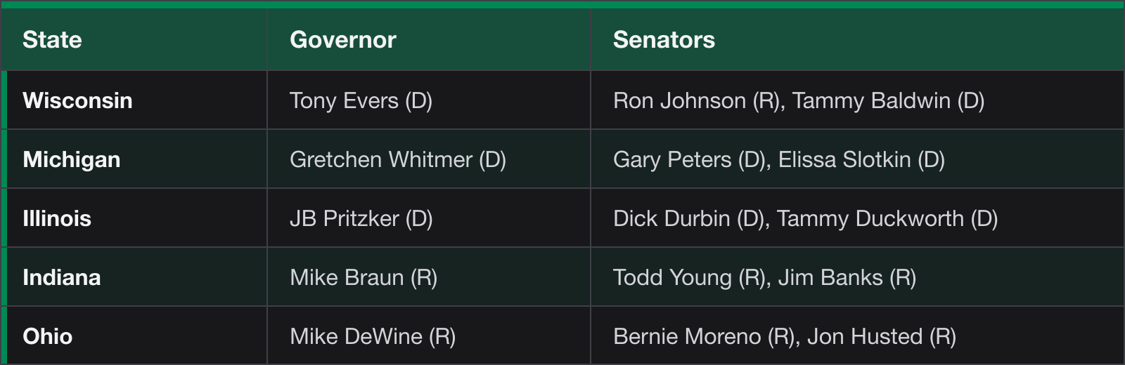
Council of 15: 8 D, 7 R.
Plains
Seven states sharing the Missouri River and the Ogallala aquifer. In 2019 Kansas and Missouri agreed to stop paying businesses to move back and forth across the state line in metropolitan Kansas City, a truce that shows how much an outbidding war costs two neighbors. What the Plains Decided Not to Change covered the region’s quieter institutions, from North Dakota’s oil fund to Minnesota’s tied legislature.
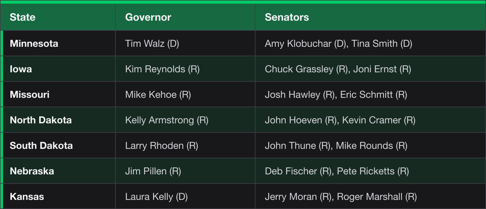
Council of 21: 4 D, 17 R.
South
Four states and a federal agency that already acts as their regional government in one domain. The Tennessee Valley Authority, created in 1933, sells power across Tennessee and parts of Alabama, Mississippi, and Kentucky, answering to a board in Washington rather than to the states it serves. The South Rises described a single coalition holding every lever in these states, and the council reflects it, eleven of twelve seats.
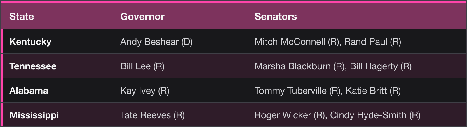
Council of 12: 1 D, 11 R.
Texas Region
The only council with no seat for the minority party. Texas runs its own power grid, deliberately kept apart from federal regulation, while its three neighbors share the Southwest Power Pool. The Red River Compact already divides that river’s water among all four.
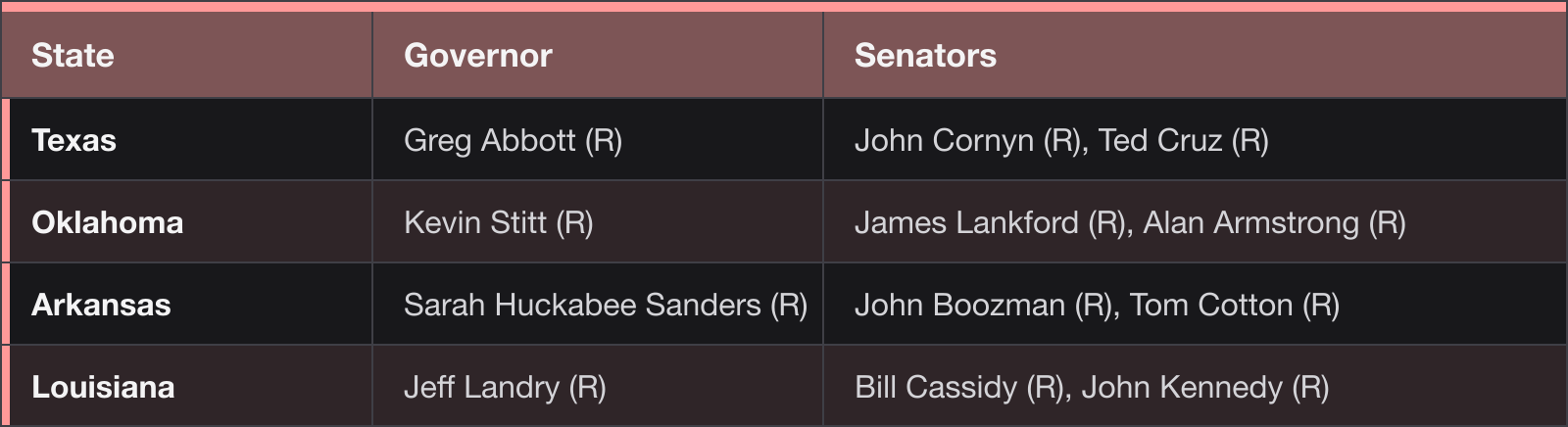
Council of 12: 12 R.
Mountain
Eight states, nearly evenly split, and the region where a regional council would have mattered most this year. Seven states signed the Colorado River Compact in 1922, and when six of them missed a federal deadline to agree on new shortage rules, the Interior Department decided for them, as The River Decides What Seven States Couldn’t reported. The seventh signatory, California, sits in the Pacific council.
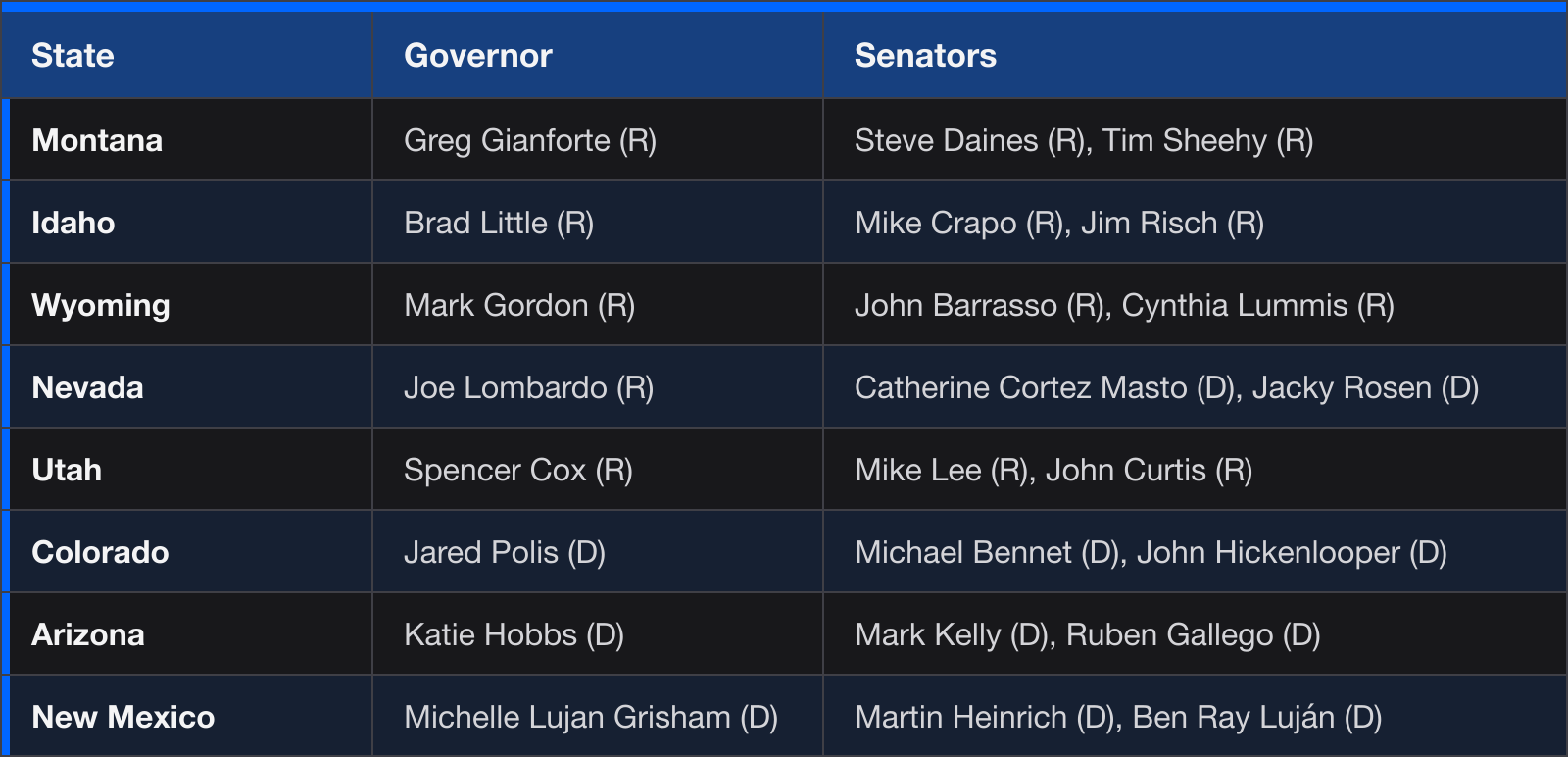
Council of 24: 11 D, 13 R.
Pacific
Three contiguous states and two that touch no other. The Northwest Power and Conservation Council, created by Congress in 1980, has governors of Washington, Oregon, Idaho, and Montana each appoint two members to plan the Columbia River’s power system, so it already crosses into the Mountain region. California’s share of the Colorado River ties it to the Mountain council as well.
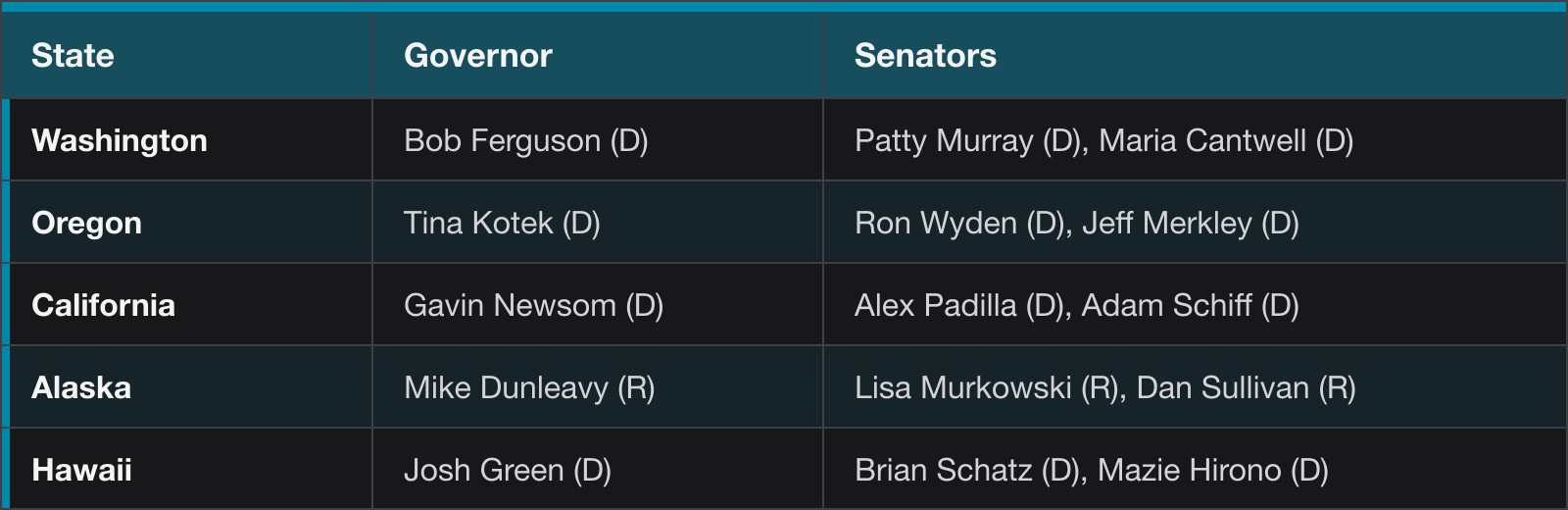
Council of 15: 12 D, 3 R.
What the rosters show
Six of the nine councils hold a lopsided majority for one party. The other three are close: the South Atlantic ties twelve to twelve, the Mountain splits thirteen to eleven, and the Lakes eight to seven. Party counts say little about how a council would vote on a river or a power grid, since the existing compacts were mostly signed by governors of both parties, and the Great Lakes Compact passed legislatures in all eight states. The Albany Plan failed in part because every colonial assembly feared a council it could not control, and Rhode Island’s exclusion in 1643 showed what a regional body could do to an unpopular member. Both failures sit underneath any regional council drawn today, whether its seats are filled by the members already elected or by people chosen for the purpose.